
Wednesday, July 6, 2016
Posted from: Buck Meadows, CA - Yosemite Ridge Resort
Miles driven: 98
Total trip miles: 4,715
Total national parks visited: 13
We have arrived. Yosemite is the epitome of a national park. It is awe inspiring and majestic.
Our campground is close to the entrance off of Highway 120, so after a short drive we were through the gate... And then we drove and drove. I told the kids this was one of my favorite parks, but so far it just looked like a lot of the others: curvy pine tree lined roads. Geez, Mom #unimpressed

But then we started driving through tunnels...

...and catching glimpses of the valley as we passed some overlooks.

And finally we arrived in the valley. Queue the music! The first thing they wanted to see was the waterfall. (Little did they know it was actually a double waterfall.)

We made the short easy hike to the bottom of the Lower and Upper Yosemite Falls.

The weather was a beautiful 78 degrees. The valley floor was busy, but we parked and used the shuttle system or walked. It worked out great.
Our main plans for the day were to hike the trails. I looked at the maps and for some reason, the description of the walk to Vernal Falls sounded really familiar. I had been to this park as a kid more than once, but could not have told you exactly which trails we walked or what we did. I was hoping to find a certain spot where a picture was taken 25 years ago, but I figured it was a shot in the dark since there are so many trails. It felt like a needle in a haystack. I wasn't planning to really spend time looking, but if we ran across it, then great. But there was still something familiar about the location, name and description of the Vernal Falls trail, so we took the shuttle to Happy Isles and started hiking.
Here is the path we took. The yellow to the green was going up. Then we took the long yellow path coming back. The green is the Mist Trail climbing up to the top of Vernal Falls.

There was something immediately familiar about this trail. I told Matt that I knew this was the one. It was a weird feeling. I even knew as we were approaching the corner where the picture was taken. I told Matt that "it is right up here somewhere." Sure enough we turned a corner and there was the rock we sat on to take that picture 25 years ago. The little red dot on the trail map above shows the picture spot.
Here is the original picture with (left to right) Steve, Dad, Carrie and me. I was rocking the bright orange fanny pack. How did those ever go out of style?! So practical. ;)

Here was our remake of the picture. It is more obvious in this picture that there is a waterfall in the background. I didn't remember that from the original picture. That probably would have helped me know for sure that this was the trail.
We actually took this picture twice. Once on the way up in the early morning when we were all in shadows, and again on the way down in the afternoon when the sun was shining like it was in the original picture.

One other thing about this trail... It is categorized as strenuous. It is so steep uphill that going back down is almost just as hard.
The Mist Trail portion was our favorite part. It was steep with just under 700 steps. These were irregular tall steps with some of them as high as my knees. We let little legs (Caleb) lead the way, but that proved to be a mistake as the kid just jumped all the way up like it was no big deal. We all had to do our best to keep up. The trail was busy but not annoyingly so. Everyone was keeping a good pace and getting off to the side if they needed to rest or take in the sights.

The constant rainbows were probably the best part. The kids loved that the waterfall rained on you the whole time.

You can see all of the people walking the trail below. It was so green and beautiful with the rainbows.

We finally made it to the top. Whew!!!

The edge of the falls. When I was here as a kid I remember that there wasn't much of a railing. We were able to walk up to the waters edge and fill out water bottles from the stream (because germs were allowed back then). Now there is a railing and signs everywhere reminding people that they have a brain and should use it to its fullest extent... And if that is not reasonably possible, we will put up fences to save you from yourself.

Emerald Pool... Again, we were very happy with our lunch stop choice. This was actually "first lunch". Our "real lunch" was back at the truck, but we always hike with enough calories to equal a couple meals just in case we find something cool and want to keep going...as was the case today. So trail mix, jerky, and bars.


We were given a tip to continue on the trail after reaching the falls and take the "crossover" path to link up with the John Muir trail. This would help us avoid going back down the wet and very busy steps on Mist Trail.
We began hiking and realized that this was a very rustic path (a couple time we had to make sure we were still on it) and we were still going up very quickly. The kids loved this path. It was a path up the side of a rock. At one point we looked over our shoulders and saw that we were now way above the Vernal Falls we had just hiked to.

We got high enough to be almost level with the Nevada Fallls which are the falls above Vernal Falls.

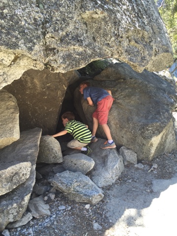
Cave explorers. (Like I said, the kids loved this trail. No one wanted to stop hiking.)
The John Muir part of the trail was made up of a series of steep switchbacks. We finally ended up back at the base of Vernal Falls which met up with our original path. We walked the rest of the way down, but by now Grace had stepped a little bit wrong on a rock and turned her ankle a bit. I had done the same, but it was my knee that seemed bothered. Going down a steep hill for 2.5 miles is hard on knees anyway.
But not once did the kids complain or say they want to go back. Even when Grace hurt her ankle with 2 miles to go. She just kept walking and smiled when we asked if she was okay.
We did learn a lesson on this hike: for the first time on this trip, we did not have enough water for the hike we took. We were fine, and ended up having plenty, but we like to have more than plenty. We hiked much farther than we had planned. Even with two water filling stations, we had empty bottles by the time we got to the bottom.
I wondered how far up we had gone. According to my iPhone, we walked up 113 flights. I believe this is very accurate. This chart shows all of the days on our trip so far. This one had the most hiking elevation change with about 1500ft increase in elevation.

Matt snapped this picture in the visitor center that had descriptions of some of the paths we took.

This is a better map of the trails we took today.
Yellow arrow: The trail we took up.
Green path: Mist Trail steps up to the top of Vernal Falls.
Red circle: Clarks Point; our highest point on the trail.
Orange arrow: the John Muir trail back down the hill. There were a lot more switchbacks, but I suppose if they put them all on the map people would never take the trail.

Our path was a total of 6.2 miles. We had already walked 3 miles before starting this path. And after we were done we walked around the Yosemite Villiage. We easily had a 10 mile day, with over six of those miles on a strenuous path...and not one complaint. This. Is. Fun.
After enjoying our "second lunch" in the Yosemite Villiage, we walked around for a while and decided to head home.
Matt voted to eat at a little pizza place he saw yesterday in Groveland. We were all so tired that he didn't get any disagreement. The pizza hit the spot!
We returned to the campsite, went for a quick swim, and slept very well.


No comments:
Post a Comment